Staying true to our purpose in the face of injustices
2025 was a hard year. The climate crisis escalates, most recently claiming over 1000 lives through flooding in Sumatra, Indonesia. Indigenous Peoples and frontline environmental defenders are increasingly recognized for the role they play in protecting biodiversity and critical ecosystems, and yet they continue to be under threat, with scores more being killed this year for their environmental work. Meanwhile, many of our team members live in countries where government leaders are openly hostile to our core values.
In the face of end times fascism, I find myself walking a delicate tightrope to bear witness to injustice while still holding fast to a vision of a more just and beautiful future.
Acknowledging the profound losses - of languages, biodiversity and human cultures - resulting from the final waves of colonization and extractivism carries an emotional and spiritual toll. Yet our work at the intersection of technology, climate justice, Indigenous rights and environmental protection is also profoundly meaningful.
Through our close collaborations, we have an intimate view of the incredible dedication, wisdom and commitment of our partners. Regardless of threats, across the world devoted environmental defenders are doing whatever they can to protect what they love. Our team is dedicated to honoring these efforts by building tools that strengthen territorial defense—without extracting knowledge or compromising sovereignty. This post reflects on what communities advanced together this year, and how Awana Digital remains committed to that work.
One Year Into Our 3-Year Strategic Plan
In 2023, our team conducted deep consultation with core partners from around the world, and in 2024 we synthesized our conversations and their recommendations into a 3-year strategic plan, which guides our team’s work and technological roadmap over this three year period ending in December 2027.
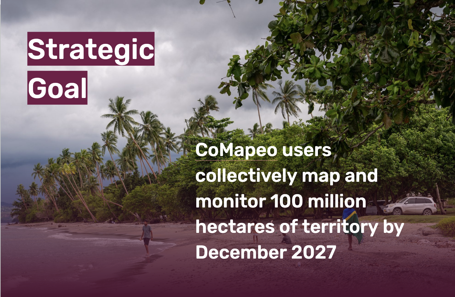
Indigenous Peoples steward approximately 80% of the world’s remaining biodiversity and 40% of its intact landscapes. Our strategic goal is to ensure these communities have the mapping and storytelling tools they need to protect their territories and cultures on their own terms. By the end of 2027, we aim for CoMapeo users to have collectively mapped and monitored 100 million hectares of land—an area more than twice the size of California.
Now that we are one-third of the way through the plan, key insights are emerging.
Focus matters.
Having the plan in place as we began the year enabled us to focus on the key elements of the plan, and say no to distractions.
This is long term work.
While our Strategic Plan provides a blueprint for this 3-year period, we recognize that defending Indigenous territories against colonization and extractive industries is a struggle that spans generations. The plan helps us focus our energies, but it is in service to our longer term commitment to our key partners. That long-term commitment in turn informs our choices, including technical ones, to focus on reducing technical dependencies and ensuring long-term data sovereignty.
Intersectionality is a strength.
When drafting the plan, we envisioned that CoMapeo projects might fall into four distinct categories (land rights, territorial management, biodiversity monitoring and reducing illegal activity). In reality, for our Indigenous partners, these use cases often blur, and a project that begins as one thing often evolves into another as circumstances change. We see this as a strength, that CoMapeo is flexible enough for communities to adapt to their evolving needs.
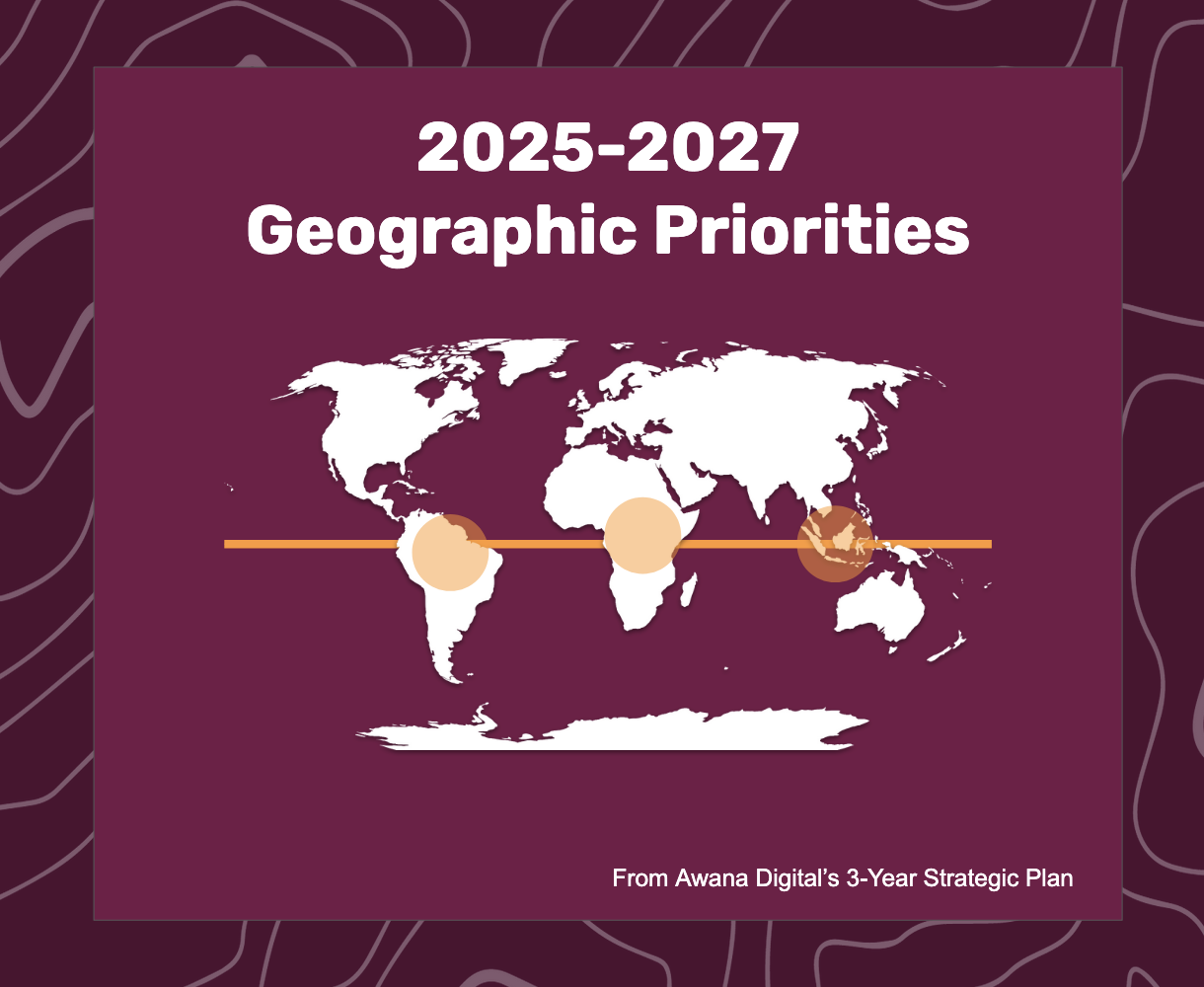
Progress on geographic expansion.
While our primary focus for the past decade has been the Amazon rainforest, since 2020 we’ve seen organic, word-of-mouth expansion to partners in other regions. For the first time, our strategic plan explicitly prioritizes geographic growth—focusing on regions with extraordinary biodiversity and escalating threats to Indigenous territories, where our tools and approaches can have the greatest impact. These focus areas include the Amazon rainforest, the Congo Basin and East Africa, and Indonesia and the Pacific Islands.
Impact Highlights: A Year of Global Environmental Defense
As of December 2025, our partners around the world have used our tools to map, monitor and defend approximately 17 million hectares of land - an area similar in size to the US State of Florida.
Key Milestones
Launch of CoMapeo Abare
In December, after three years of co-development, we launched the first public version of CoMapeo Mobile, CoMapeo Abare. Designed with Indigenous communities for environmental defenders everywhere, the tool prioritizes ease of use, security and data sovereignty.
Mapeo Impact Report
To celebrate the launch of CoMapeo, we took a look back at its predecessor, Mapeo, and published a report highlighting the victories, stories, and statistics from the past decade of its use around the world.
Geographic Expansion
In addition to our existing partners, in the Amazon and east Africa, we connected with, trained, and supported Earth Defenders in new regions, including Indonesia, Thailand, and West and Central Africa.
Community Led Victories
Brazil (Kaxuyana–Tunayana): 2.1 million hectare territory announced at COP30
Following COP30 commitments, Brazilian President Lula da Silva recognized ten new Indigenous lands, including 2.1M hectares for our partners from Kaxuyana/Tunayana Territory, a huge victory for the Indigenous Peoples of Brazil and one that will help protect millions of hectares of critical Amazonian rainforest.
Brazil: Indigenous women leading monitoring
In Brazil, we’ve co-hosted a series of Indigenous women-focused mapping and monitoring workshops that considerably strengthened the leadership capacity of women earth defenders from three of our Indigenous partner-communities. Collectively, these women are fighting to protect over 470,000 hectares of critical rainforest and cerrado ecosystems, and took the global stage as active participants in the March of Indigenous Women of Brazil in August and COP 30 in November.
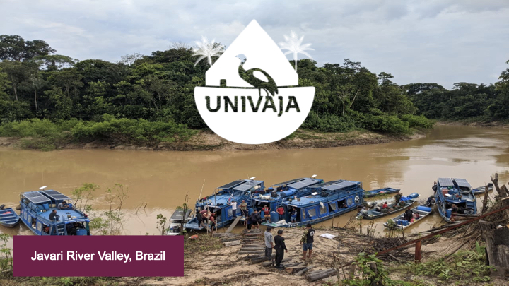
Brazil (Javari River Valley): Univaja expanded their monitoring program to defend 8.5M hectares
In the Vale do Javari, the second largest territory in Brazil, our partners Univaja have been using CoMapeo to monitor threats including drug trafficking, illegal mining and illegal fishing. Univaja is an Indigenous organization representing the 7,000 inhabitants of the valley, including 19 uncontacted Peoples. In July our team was honored to participate in the next phase of their program, where 112 participants were trained, as they expand their monitoring efforts to the entire 8.5 million hectares of the Javari Valley, an area roughly the size of Portugal.
Kenya: Launch of biodiversity monitoring program
Our longtime partners in Kenya, the Ogiek of Mt. Elgon, formally launched a community-based biodiversity monitoring program using CoMapeo to collect data on the health of the ecosystem within areas of their ancestral territory to which they recently won legal rights. The community is already using the data to improve their own stewardship of their lands, and planning to leverage this evidence of effective community-based conservation in their legal work to regain rights over remaining areas of their ancestral lands.
Tanzania: Community defense against evictions
Our Maasai partners in Ngorongoro, Tanzania have continued to fight against evictions by the Tanzanian government. In 2024, they mapped 96% of their lands and expanded to new areas to document ongoing rights violations against Maasai communities. This year, their maps and data informed a Presidential Commission reviewing the future of the Ngorongoro Conservation Area and supported efforts to map remaining territory, with a focus on documenting land use to help prevent further evictions.
Emerging Use Cases
In addition to these long-standing partnerships, we’re seeing CoMapeo adopted in new regions and for new challenges — often in ways we couldn’t have predicted.
Nigeria: Oil spill documentation
In the Niger Delta, youth led organization Tech4Rural has trained a team of 40 young monitors to use CoMapeo to collect evidence of the continuous oil spills in the region. Their vision is to build a volunteer network of thousands, shifting the narrative and taking meaningful, community-led action to protect coastal Nigeria.
Brazil: Cassava plant tracking
In the Tumucumaque territory of Brazil, community mappers are using CoMapeo to closely track a disease epidemic that is killing cassava plants and deeply impacting the food sovereignty of these communities. The data collected will be shared with the National Agronomy Agency, enabling government responses informed by local knowledge.
Thailand: Ecosystem and climate resilience monitoring
For Karen communities in western Thailand, climate change is dramatically affecting the rivers they depend on. This fall, in partnership with IMPECT Thailand, they launched a program to monitor the shifting biodiversity of the area to increase their resilience in the face of climate impacts.
Collaboration as a Force Multiplier
Collaboration is central to how Awana Digital works. Lasting impact is never achieved alone, and many of our partners’ victories are made possible through networks of trust, shared expertise, and long-term commitment. In 2025, several collaborations played a critical role in extending our reach and strengthening our impact.
We saw strong peer-to-peer growth, with partners going on to train others—from the Ogiek-led organization CIPDP in Kenya working with nearby Sengwer communities, to the Wayana-led Mulokot Foundation in Suriname supporting Wayana communities in French Guiana. We expect this community-led expansion to continue in 2026.
Long-standing partnerships also opened new pathways. Forest Peoples Programme (FPP) brought us in to support community partners across Central and Eastern Africa, Colombia, Peru, and Thailand, complementing our technical work with their decades of rights-based legal and advocacy support. At the same time, our collaboration with Conservation Metrics, Imazon, and Nia Tero deepened on our joint work on a biocultural monitoring workflow grounded in Indigenous Data Sovereignty.
These collaborations reflect what energizes us: impact rooted in relationships, shared values, and collective commitment over time.
What Gives Us Hope
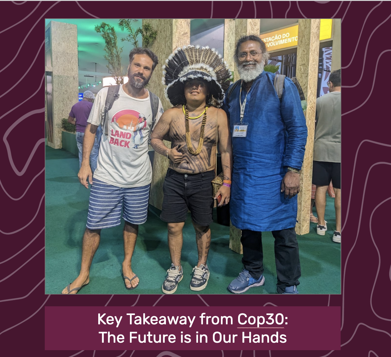
At the end of this long year, I keep returning to a reflection shared by one of Awana Digital’s board members, Pooven Moodley, after his participation at COP30. Yes, it is deeply demoralizing that so many governments and corporations remain unwilling to set aside fossil fuel dependence in favor of a livable planet for future generations. But we can’t let that be our story. This planet is too precious, and life too sacred, for us to give up. We cannot rely on the same forces that created these crises to fix them. The future is in our hands, and it is up to us to defend what still remains. As long as there are places and beings worth defending, we have a reason to keep going.
The progress and bright spots of this year were only possible because of many layers of connection and commitment. I am deeply grateful for our inspiring community partners, our dedicated team members, our supportive funders, and our many collaborators. I feel energized by what lies ahead—as more communities begin using CoMapeo, and as our partnerships continue to deepen in the year to come.
With solidarity and gratitude,
Emily Jacobi
Will you help us support even more frontline communities in 2026? We invite you to become a monthly donor and stay connected to our work as we continue strengthening the efforts of Earth defenders safeguarding the planet for future generations.