Co-designed with Indigenous Communities — Built for Earth Defenders Everywhere
From forest guardians to community organizers, thousands of protectors of land and life are already using CoMapeo to defend ecosystems and document environmental threats around the world. Now, with the launch of CoMapeo Abare, these tools are more accessible and secure than ever, and poised to support communities to protect over 100 million hectares of critical ecosystems over the next three years.
Protect What You Love — Start Using CoMapeo Abare Today
- Download CoMapeo Abare (free & offline-ready)
- Sign up to receive CoMapeo updates, new features, and stories from our global community of Earth defenders
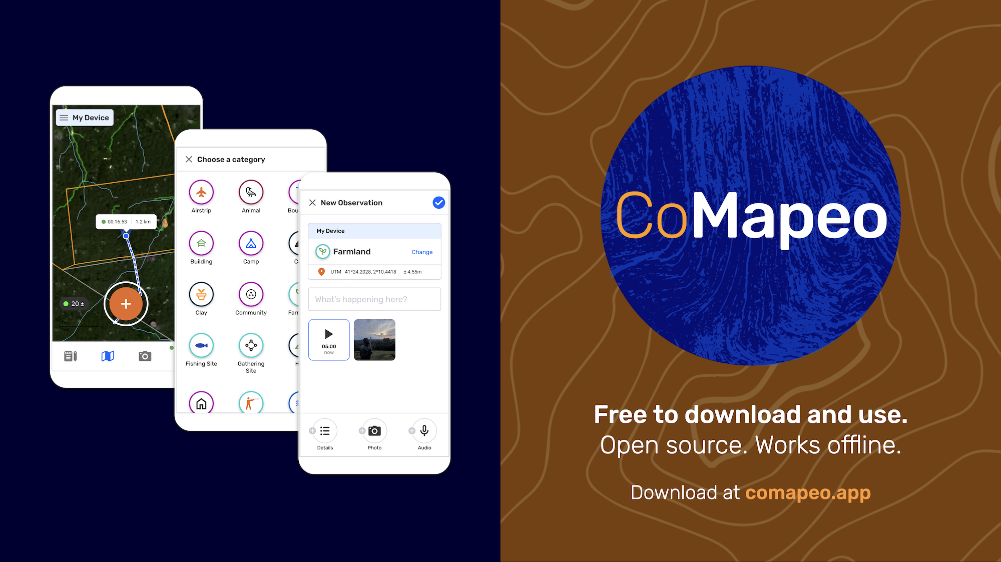
Today, Awana Digital is proud to introduce CoMapeo Abare, an open-source Android app designed with Indigenous communities for environmental defenders everywhere. CoMapeo enables non-technical users to easily map and document biodiversity, environmental threats, and human rights abuses. Whether you are a forest guardian, land steward, researcher, or community advocate, CoMapeo gives you the tools to protect what you love — even offline.
Abare marks the first public release of CoMapeo Mobile—an evolution of nearly a decade of hands-on field testing and co-development with Indigenous communities protecting their territories from contamination, deforestation, and climate impacts. With the push of a button, users can collect data, link GPS points, take photos and audio recordings, and record notes. All information is stored directly on local devices through a peer-to-peer database, meaning communities—not servers—own and control their data. Nothing leaves the device unless a community chooses to share it.
CoMapeo is simple, free, accessible, secure, and supports translation into local languages as well as customized settings and offline maps.
“Over 25 years working with Indigenous Peoples I’ve seen the power of maps and technology for documentation and advocacy. I’ve also seen the limitations of existing tools built for an always-connected world and designed for reviewing coffee shops rather than documenting oil spills. We built CoMapeo with frontline communities to meet their specific needs,”
— Gregor MacLennan, Technology Director, Awana Digital
Why CoMapeo Matters
Maps, photos, and GPS points are powerful tools for Indigenous and frontline communities responding to oil spills, illegal logging, forced displacement, and ecological harm. Yet many existing tools can be disempowering: they often require outside technical expertise, rely on internet access, prioritize English, or store data on external servers beyond community control.
CoMapeo was shaped through long-term collaboration with partners on the ground to address these gaps, building on the decade-long impact of Mapeo—a global tool used in more than 90 countries across six continents, where communities have mapped, monitored, and protected over 17 million hectares of land and forest. CoMapeo is the next-generation evolution of this work, stewarded by Awana Digital alongside Indigenous and frontline environmental defenders worldwide.
About CoMapeo Abare
CoMapeo is the result of a multi-year co-design process with communities around the world to build a tool tailored to frontline environmental defenders. “Abare”—meaning Condor—comes from the Waorani people of Ecuador, some of the earliest adopters of Mapeo. The Waorani used Mapeo to map nearly 200,000 hectares of ancestral lands, work that later contributed to a landmark legal victory preventing oil drilling on their territory.
They suggested the name because condors are powerful birds that appear in moments of great need.
“The Ne Wanonani Meñebai, the Indigenous guard responsible for monitoring and recording harmful activities, have been using Mapeo for years. It is so easy to use that even our elders—who do not speak Spanish—use it. We look forward to using CoMapeo Abare and seeing how it strengthens our community-led monitoring. Technology is an extension of our knowledge.”
— Opi Nenquimo, Leader of the Waorani Mapping Project & President of OWAP
%2520(2).png)
“Condor” by Pedro Szekely, CC BY-SA 2.0
Key Features
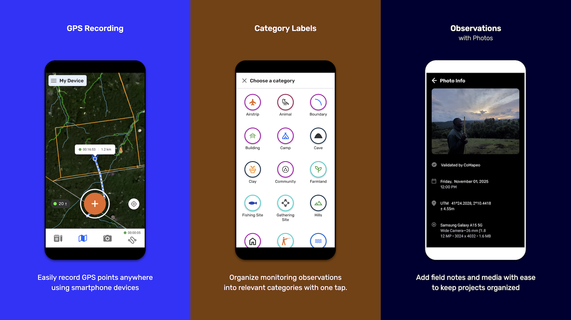
Powerful Data Collection
With one tap, users can capture data points enriched with photos, audio, GPS coordinates, dates, and categorized details. Tracks allow users to map routes and add deeper context to evidence and territory storytelling.
Offline Collaboration
CoMapeo is fully offline—not just for data gathering, but also for team collaboration. A peer-to-peer database allows groups to securely exchange data without the internet, in regions where access is censored or unreliable.
Projects
Projects are private, encrypted collaborative maps. Project creators control who can access or contribute, ensuring that all shared data remains within trusted networks.
Simple, Strong Security
Data is encrypted both at rest and in transit, but CoMapeo avoids complicated logins. Each device generates cryptographic keys, ensuring data cannot be intercepted or read by outsiders.
Data Ownership
All data stays stored locally on user devices—never in the cloud, never on Awana servers, and never on third-party infrastructure unless users explicitly choose to export or share it.
Multilingual & Customizable
Already translated into 23 languages, CoMapeo can be easily adapted into local languages. Categories and icons can be customized to reflect local ecosystems, threats, and cultural contexts.
“From the Waorani mapping project that helped protect the Ecuadorian rainforest to halting illegal logging in the Solomon Islands, we’ve seen firsthand the powerful ways local communities are defending critical ecosystems using our tool. We’re excited to launch CoMapeo Abare to help more communities around the world protect what they love.”- Emily Jacobi, Co-Founder and Executive Director, Awana Digital
CoMapeo in Action
CoMapeo is already supporting community-led monitoring, land rights advocacy, biodiversity research, and climate resilience around the world.
Brazilian Amazon
In the Javari Valley, Univaja uses CoMapeo to patrol 8.5 million hectares—an area the size of Belgium—against threats from illegal mining, fishing, and drug trafficking.
Kenya
The Ogiek people of Mt. Elgon, through CIPDP, are using CoMapeo in a groundbreaking biodiversity monitoring project that blends scientific methods with Traditional Ecological Knowledge. Community members record bird songs and forest audioscapes for identification by elders.
Thailand
In Mae Yang Min, Karen community members, in collaboration with IMPECT, use CoMapeo to document ecosystem changes and strengthen community-led conservation grounded in sacred practices and climate resilience.
Learn More
Read more about the legacy of Mapeo and CoMapeo’s impact: Impact Report - Ten Years of Mapeo
Protect What You Love — Start Using CoMapeo Abare Today
- Download CoMapeo Abare (free & offline-ready)
- Sign up to receive CoMapeo updates, new features, and stories from our global community of Earth defenders
.png)